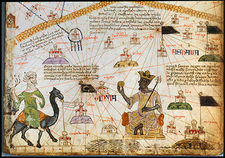
The well-known Catalan atlas of 1375 is credited to Abraham Cresques, a fourteenth century Jewish cartographer from the island of Majorca. The atlas was divided into six large panels. Panel three, the source of the atlas excerpt above, shows principal points along the trans-Saharan trade routes in west and north Africa, as well as camel caravans and some of the major trade goods exchanged—gold, copper, iron, horses, salt, textiles, leather goods, ivory, and captive peoples. The major city, intellectual center, and trade destination of Timbuktu, then a part of the Mali Empire, is indicated on the atlas. Equally important are two inscriptions written in Catalan and Spanish on the atlas. The first reads, “The merchants that enter the land of the blacks of [Guinea] pass through this place; this pass is called Valley of Darcha.” The second inscription, pointing to the power and wealth of Mali and its ruler, reads, “This Black lord is called Musse Melly [mansa Musa Keita of Mali, r. 1312-37], lord of the Blacks of Guinea. The king is the richest and most distinguished ruler of this whole region, on account of the great quantity of gold that is found in his land.”
The trans-Saharan trade network preceded the Arab invasion of North Africa by centuries. The trade system involved primarily western and northern Africa, using horse-powered, chariot-like vehicles well before the introduction of the camel in the first century CE. In fact, three to eight-thousand-year-old rock art found in the caves and rock shelters of the Sahara region show these horse-drawn chariots and ox-drawn carts. Whether with these vehicles or the camel, common trade items transported and exchanged across the Saharan region included (rock) salt, beads, cloth, dried fruits, smoked fish, horses, copper, gold, ivory, kola (nuts), and captive peoples. The introduction the camel and Islam—with its legal codes and literacy—expanded the trade in these commodities and especially in gold, bringing Amazigh (“Berber”) peoples of the northern Sahara and Africans of the savanna region to the south into greater contact and at times into conflict. Between the Sahara Desert and the tropical rainforest, the west African savanna was endowed with livestock, cereal agriculture as well as gold, iron ore, pottery clay and stone. The savanna linked the desert and the forest through camel-to-canoe or camel-to-donkey transportation. More broadly, the trans-Saharan trade connected the Mediterranean lands with internal African grasslands from the Atlantic coast in the west to the Nile river in the east.
Sources: Abraham Cresques, Atlas de cartes marines, Bibliothèque nationale de France, Département des manuscrits, Espagnol 30. See also Georges Grosjean, ed., Mapamundi: The Catalan Atlas of the year 1375, trans. B. M. Charleston (Dietikon, Zurich: Urs Graf, 1978), 53; Felipe Fernandez-Armesto, Before Columbus: Exploration and Colonization from the Mediterranean to the Atlantic, 1229-1492 (Philadelphia: University of Pennsylvania Press, 1987), 148-151.